
A City Re-Shaped
by the Streetcar
If viewing this project on mobile, click here to view the map in another tab
Kansas City, my home town, once had one of the most extensive streetcar networks in the US. At its height, 25 different streetcar lines crossed both Kansas City, Missouri and Kansas City, Kansas, and some nearby suburbs — shaping neighborhoods, connecting people to jobs, and building a foundation for regional growth.
Then, as in so many other American cities in the mid 20th century, we tore it all out. The cost of maintenance combined with the growing popularity of the automobile ultimately led to the demise of the system. Before we saw the dawn of the 1960s, the streetcars were gone.
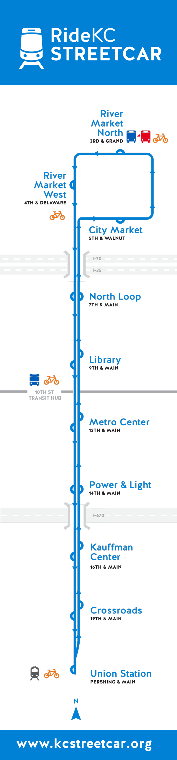
Half a century later, in 2016, the city opened a new 2.2-mile modern streetcar line along Main Street. Though modest in size, it was free to ride, easy to use, and – crucially – embraced by residents and tourists alike. It continues to spur billions in new development and regularly exceeds ridership expectations. Voters have since approved a 3.5-mile extension south to UMKC, now under construction and scheduled to open in 2025. A smaller extension to Berkley Riverfront is also in the works.
It’s exciting progress. But I couldn’t help wondering: What would it look like if Kansas City went all in?
🚈 What If Kansas City Built a Real Streetcar Network?
That’s the thought experiment behind this map: a vision for a more ambitious streetcar revival — not just a downtown loop or a symbolic investment, but a comprehensive system that could genuinely reshape how people get around Kansas City.
AT A GLANCE
🔁 7 new lines, spanning both sides of the state line
📍 142 new stops, reaching deep into neighborhoods
🛤️ Nearly 80 miles of track — over 25% more than Toronto’s largest-in-North-America system
💵 Estimated cost: ~$4 billion
💼 Tens of thousands of jobs connected by walkable, reliable transit
It’s an imagined system, not a funded one, but it’s grounded in real routes, real demand, and real need. Some corridors follow former streetcar routes. Some would replace high-ridership bus routes. Others serve dense housing, job centers, hospitals, schools, or underserved neighborhoods. All of them stitch together a city that too often feels disconnected, and is leaving too many of its citizens behind.
Let’s take a closer look at each line — starting with the one already in progress: the Main Street Line.
🔵 Main Street Line
ROUTE
River Market → 75th Street / 63 St & Swope Pkwy / Swope Park
A further Main Street extension to as far as population density will allow; plus an arm reaching into the southeast side’s premier outdoor space: Swope Park.
📏 Total New Mileage
6.8 mi
🚏 No. of New Stops
11
↔️ Avg. Stop Spacing
0.62 mi
💰 Est. Construction Cost
$344,100,900
💵 Cost per Stop
$31,281,900
$31,281,900
🗺️ Key Destinations (within 0.25 mi of a stop)
- City Market
- US District Court
- Kansas City City Hall
- Jackson County Courthouse
- Bartle Hall
- Municipal Auditorium
- Kansas City Music Hall
- T-Mobile Center
- Power & Light District
- Kauffman Center for the Performing Arts
- Union Station
- Crown Center
- Liberty Memorial
- National WWI Museum
- IRS Kansas City
- Federal Reserve Bank of Kansas City
- Hallmark Corporate
- Metropolitan Community College Penn Valley Campus
- St. Luke’s Hospital
- The Nelson-Atkins Museum of Art
- Kansas City Art Institute
- Kemper Museum of Modern Art
- University of Missouri – Kansas City
- Loose Park
- The National Museum of Toys and Miniatures
- Research Medical Center
- Swope Park
- Starlight Theatre
- Kansas City Zoo & Aquarium
🏘️ Neighborhoods Served:
- River Market
- Downtown
- Quality Hill
- Garment District
- Crossroads
- Longfellow
- Union Hill
- Hyde Park
- Westport
- Country Club Plaza
- Brookside
- Waldo
Let’s dive into the map starting with the Main Street line. My own Main Street Extension, as it were. This proposal includes the nearly-completed extension to 51st St, but I send the line further south still, to 75th Street in Waldo via Brookside Blvd and Wornall Road. (Where, exactly, the line would jump from Brookside Blvd to Wornall Road is up for debate: it could happen at 63rd Street, or at Meyer Blvd, or it could reclaim the space formerly dedicated to the original streetcar that ran here: the Trolley Trail, now a popular jogging path.)
In addition, I’ve introduced a spur along 63rd Street, allowing some streetcars to turn east and end either at 63rd & Swope Parkway or inside Swope Park proper, with a final stop near Zoo Drive — right between the Kansas City Zoo & Aquarium and Starlight Theatre.
The Swope Park stop is marked as a Special Service route — meaning it wouldn’t run all day, every day, but instead operate during high-demand times like weekends, holidays, or before and after evening events at Starlight. It’s a flexible solution that brings service where and when it’s most needed, and it’s one I utilize a number of times in this proposal.
![]() Starlight Theatre
Starlight Theatre
This line reflects one of my biggest goals: to strengthen cross-town connectivity. By linking with all seven other routes, it would be the backbone of the system, making it easier for riders to move between neighborhoods that haven’t traditionally had strong transit connections, and open up whole new parts of the city to more people.
In addition, I’ve introduced a spur along 63rd Street, allowing some streetcars to turn east and end either at 63rd & Swope Parkway or inside Swope Park proper, with a final stop near Zoo Drive — right between the Kansas City Zoo & Aquarium and Starlight Theatre.
The Swope Park stop is marked as a Special Service route — meaning it wouldn’t run all day, every day, but instead operate during high-demand times like weekends, holidays, or before and after evening events at Starlight. It’s a flexible solution that brings service where and when it’s most needed, and it’s one I utilize a number of times in this proposal.
 Starlight Theatre
 This line reflects one of my biggest goals: to strengthen cross-town connectivity. By linking with all seven other routes, it would be the backbone of the system, making it easier for riders to move between neighborhoods that haven’t traditionally had strong transit connections, and open up whole new parts of the city to more people.
🔴 Broadway / Independence Line
ROUTE
Independence Ave & Hardesty Ave → West Plaza
A major L-shaped line that connects the city’s underrated Northeast with one of its best corridors via the Downtown Loop.
📏 Total New Mileage
7.5 mi
🚏 No. of New Stops
20
↔️ Avg. Stop Spacing
0.36 mi
💰 Est. Construction Cost
$379,236,000
💵 Cost per Stop
$18,058,857
$18,058,857
🗺️ Key Destinations (within 0.25 mi of a stop)
- Kansas City University
- US District Court
- Bartle Hall
- Municipal Auditorium
- Kansas City Music Hall
- Kauffman Center for the Performing Arts
- Boulevard Brewing
- Penway Point
- KC Wheel
- IRS Kansas City
- Metropolitan Community College Penn Valley Campus
- Uptown Theater
🏘️ Neighborhoods Served:
- Pendleton Heights
- Northeast
- Garment District
- Quality Hill
- Crossroads
- Valentine
- Westport
- Country Club Plaza
- West Plaza
Even though it runs less than half a mile from the Main Street line, the Broadway segment of the Broadway/Independence line plays an important role in this proposal. Streetcars don’t just move people, they also shape the streets they run on. Like Main, Broadway already has strong pockets of urban vitality. A streetcar here would build on that energy, helping support density, walkability, and neighborhood vibrancy. It would also offer front-door access to two of downtown’s biggest civic draws: the Kauffman Center for the Performing Arts and Bartle Hall.
![]() Kauffman Center for the Performing Arts
Kauffman Center for the Performing Arts
Heading east, the Independence Ave portion brings the line into some of the city’s more economically diverse, and historically vibrant, neighborhoods. This plan could provide the spark it needs to increase the corridor’s economic activity.
For full Northeast coverage, a future additional line or spur on St. John Ave should be considered. It could split off north from Independence Ave through Pendleton Heights on Maple Blvd, then east on Lexington Ave before shooting up to St. John at Bellefontaine and out all the way to Belmont Blvd.
 Kauffman Center for the Performing Arts
Heading east, the Independence Ave portion brings the line into some of the city’s more economically diverse, and historically vibrant, neighborhoods. This plan could provide the spark it needs to increase the corridor’s economic activity.
For full Northeast coverage, a future additional line or spur on St. John Ave should be considered. It could split off north from Independence Ave through Pendleton Heights on Maple Blvd, then east on Lexington Ave before shooting up to St. John at Bellefontaine and out all the way to Belmont Blvd.
🟢 Oak/Gillham/Troost Line
ROUTE
Barry Rd. → 63rd Street
Connections to jobs and entertainment for the Northland and East Side on the system’s second-longest line
📏 Total New Mileage
16.2 mi
🚏 No. of New Stops
25
↔️ Avg. Stop Spacing
0.62 mi
💰 Est. Construction Cost
$821,390,700
💵 Cost per Stop
$31,591,950
$31,591,950
🗺️ Key Destinations (within 0.25 mi of a stop)
- US District Court
- City Hall
- Jackson County Courthouse
- T-Mobile Center
- Children’s Mercy Hospital
- Crown Center
- Hallmark Corporate
- Truman Medical Center
- University of Missouri – Kansas City
- Stowers Institute
- Rockhurst University
🏘️ Neighborhoods Served:
- Gladstone
- North Kansas City
- East Village
- Crossroads
- Hospital Hill
- Longfellow
- Union Hill
- Hyde Park
- Manheim Park
- Blue Hills
- Brookside
A streetcar system that doesn’t begin to serve residents of Kansas City’s historically underinvested East Side risks failing the very communities that could most benefit from its creation. For decades, areas east of Troost Ave have faced systemic disinvestment and limited access to jobs. If we’re serious about building a public transit system for the whole city, this part of town can’t be an afterthought. It has to be a priority.
This line, along with the 12th/Prospect/Truman line, is one of this proposal’s clearest efforts to bridge that divide. It serves neighborhoods where reliable, affordable transit can have the biggest impact, connecting people to job centers, medical care, and civic services without the burden of car ownership.
It’s also the second line in our proposal so far that extends Special Service into the metro’s suburbs – in this case, Kansas City’s Northland, via North Oak Trafficway. The role of these Northland stops is open to discussion: they could serve as classic park-and-rides, with adjacent parking for commuters, or become the foundation for Transit-Oriented Development – compact, walkable districts with mid-rise housing and commercial activity designed around high-frequency transit.
Whatever role the Northland stops play, the core utility of this line lies in what it connects. Running down Oak Street and into the Downtown Loop, it provides immediate access to critical civic institutions like City Hall, the Jackson County Courthouse, the U.S. District Courthouse, and the T-Mobile Center. As Oak becomes Gillham Rd near Hospital Hill, the line continues past Children’s Mercy, Truman Medical Center, and UMKC’s Schools of Pharmacy and Dentistry. It also puts riders within a short walk of Crown Center and Hallmark’s corporate campus, two key anchors for tourism and jobs, respectively, in the urban core.
At Linwood Blvd, the route turns east off Gillham, briefly parallels the Linwood Line, then heads south on Troost. It intersects the 39th Street and 47th Street lines before ending at the 63rd Street spur of the Main Street line.
So why not stay on Gillham? Why jog over to Troost at Linwood? For one, Gillham becomes almost entirely residential south of Linwood, with fewer destinations to support strong ridership. Troost, by contrast, was once one of Kansas City’s great commercial streets, and while it’s now dotted with vacant lots and underused storefronts, the bones of a walkable, vibrant corridor are still there: wide sidewalks, corner buildings, and a grid that invites revitalization. Additionally, bus ridership on this southern stretch of Troost is stronger than it is to the north, and a streetcar line would meet that demand while encouraging reinvestment. Routing the line down Troost isn’t just a smart transit decision. It’s the right one.
![]() Troost Avenue Between 31st and Linwood in 1935, looking south. Courtesy of the Kansas City Public Library
Troost Avenue Between 31st and Linwood in 1935, looking south. Courtesy of the Kansas City Public Library
![4225 Troost Avenue in 1926, looking south]() 4225 Troost Avenue in 1926, looking south. Courtesy of the Kansas City Public Library
4225 Troost Avenue in 1926, looking south. Courtesy of the Kansas City Public Library
![]()
63rd and Troost Shopping Center in 1927. Courtesy of the Kansas City Public Library. Here is the shopping center in 2022.
This line, along with the 12th/Prospect/Truman line, is one of this proposal’s clearest efforts to bridge that divide. It serves neighborhoods where reliable, affordable transit can have the biggest impact, connecting people to job centers, medical care, and civic services without the burden of car ownership.
It’s also the second line in our proposal so far that extends Special Service into the metro’s suburbs – in this case, Kansas City’s Northland, via North Oak Trafficway. The role of these Northland stops is open to discussion: they could serve as classic park-and-rides, with adjacent parking for commuters, or become the foundation for Transit-Oriented Development – compact, walkable districts with mid-rise housing and commercial activity designed around high-frequency transit.
Whatever role the Northland stops play, the core utility of this line lies in what it connects. Running down Oak Street and into the Downtown Loop, it provides immediate access to critical civic institutions like City Hall, the Jackson County Courthouse, the U.S. District Courthouse, and the T-Mobile Center. As Oak becomes Gillham Rd near Hospital Hill, the line continues past Children’s Mercy, Truman Medical Center, and UMKC’s Schools of Pharmacy and Dentistry. It also puts riders within a short walk of Crown Center and Hallmark’s corporate campus, two key anchors for tourism and jobs, respectively, in the urban core.
At Linwood Blvd, the route turns east off Gillham, briefly parallels the Linwood Line, then heads south on Troost. It intersects the 39th Street and 47th Street lines before ending at the 63rd Street spur of the Main Street line.
So why not stay on Gillham? Why jog over to Troost at Linwood? For one, Gillham becomes almost entirely residential south of Linwood, with fewer destinations to support strong ridership. Troost, by contrast, was once one of Kansas City’s great commercial streets, and while it’s now dotted with vacant lots and underused storefronts, the bones of a walkable, vibrant corridor are still there: wide sidewalks, corner buildings, and a grid that invites revitalization. Additionally, bus ridership on this southern stretch of Troost is stronger than it is to the north, and a streetcar line would meet that demand while encouraging reinvestment. Routing the line down Troost isn’t just a smart transit decision. It’s the right one.
 Troost Avenue Between 31st and Linwood in 1935, looking south. Courtesy of the Kansas City Public Library
 4225 Troost Avenue in 1926, looking south. Courtesy of the Kansas City Public Library
63rd and Troost Shopping Center in 1927. Courtesy of the Kansas City Public Library. Here is the shopping center in 2022.
🟡 12 Street/Prospect/Truman Line
ROUTE
18th Street in KCK → 63rd Street and Prospect Ave / Downtown Independence
Reconnecting the twin Kansas Cities while increasing access for the East Side via the longest line in the system
📏 Total New Mileage
19.7 mi
🚏 No. of New Stops
39
↔️ Avg. Stop Spacing
0.50 mi
💰 Est. Construction Cost
$998,283,000
💵 Cost per Stop
$25,597,000
🗺️ Key Destinations (within 0.25 mi of a stop)
- Kansas City Kansas Public Library: Main Branch
- Wyandotte County Courthouse
- Strawberry Hill Museum
- West Bottoms Haunted Houses
- Bartle Hall
- Municipal Auditorium
- Kansas City Music Hall
- T-Mobile Center
- Jackson County Courthouse
- Kansas City Missouri City Hall
- US District Courthouse
- Research Medical Center
- Community of Christ Temple
- Historic Truman Courthouse
- Harry S Truman National Historic Site Visitor Center
- 1859 Jail Museum
- Harry S Truman National Historic Site
🏘️ Neighborhoods Served:
- Downtown Kansas City, Kansas
- Strawberry Hill
- West Bottoms
- Stockyards District
- Quality Hill
- Power & Light
- East Village
- Santa Fe
- Blue Hills
- Englewood (Independence)
This might be the most important line in the entire proposal. It links several of the metro’s most under-resourced communities – Kansas City, Kansas; Independence, Missouri; and the Prospect Ave corridor from 12th Street to 63rd – directly to the economic engine of downtown Kansas City, Missouri. Prospect, in particular, already has some of the highest bus ridership in the city, which signals both existing demand and the need for better infrastructure to serve it.
Yes, this is the longest, and therefore most expensive, line in the system, but its value is hard to overstate. Like Troost in the line above, most of this route runs through dense, pre-automobile-era neighborhoods with solid urban bones. That means an existing framework of street grids, sidewalks, and corner retail buildings that are primed for reinvestment. Despite its length, this line maintains an average of just half a mile between stops – tight spacing that matches the walkability of the neighborhoods it serves.
This line features a second system spur. On the west end, all trains terminate at 18th Street in Kansas City, Kansas, which includes a run through Strawberry Hill, one of my personal favorite neighborhoods in the metro. Through the Downtown Loop, trains run on 12th Street, turning south on Prospect Ave. At Truman Rd, the route splits: one turns east on Truman out to Independence, while the others continue south on Prospect to the terminus at 63rd and Main Street. Regular Truman Rd service would stop at Bennington Ave – the last major north-south street within the historic urban boundaries – but Special Service trains (think Rush Hour) would continue to downtown Independence.
Independence, like KCK, is a historic city with a traditional urban core, and figuring out how best to reach it was one of the tougher design choices in this proposal. One option was to stay on Truman Rd all the way in, which would have allowed a stop at the Harry S. Truman Presidential Library & Museum before dropping into downtown Independence. The other was to go along Winner Rd, through the pedestrian-scaled neighborhood of Englewood, a corridor that could really use a boost.
I didn’t feel like I could hit both Englewood and the Truman Library without compromising the simplicity of the route. In the end, I chose Englewood. I’ll admit to having mixed feelings about bypassing the Truman Library, but ultimately it came down to a tradeoff: serving a single destination vs. supporting a neighborhood with walkable bones, local businesses, and real potential for reinvestment. Englewood is the kind of corridor a streetcar can help bring back to life, and that tipped the balance for me.
⚪ The Downtown Loop
The four lines discussed above – the Main Street Line, the Broadway/Independence Line, Oak/Gillham/Troost, and 12th/Prospect/Truman – converge in the central business district and forms what this plan calls the Downtown Loop. The Loops is bounded by:
- Admiral Blvd/7th St to the north
- Oak St to the east
- 12th St to the south
- Broadway Blvd to the west
For the sake of visual clarity, the map simplifies this section by merging all four lines into a single white track with a bold black outline, but under the hood, each line interacts with the Loop in its own way. Here's how they actually move through it:
🔵 Main Street
The Main Street Line doesn’t loop so much as pass through, but it intersects the Downtown Loop at two stations:
- North Loop
- Metro Center
🔴 Broadway / Independence
West Plaza-bound streetcars enter at Admiral Blvd & Oak St, travel south on Oak with stops at East Village and City Hall, turn west, stopping at Metro Center and Quality Hill before heading south out of the Loop.
Hardesty Ave-bound streetcars re-enter the Loop at Quality Hill, then continue north through Garment District and 7th St, turn east, stop at North Loop and Admiral Blvd before heading east on Independence Ave.
🟢 Oak/Gillham/Troost Line
Southbound streetcars enter the Loop at Oak & Admiral, turn west and travel counterclockwise, stopping at North Loop, 7th St, Garment District, Quality Hill, Metro Center, and City Hall before exiting and continuing south.
Northbound trains enter at City Hall, continue north on Oak, and stop at East Village and Admiral Blvd before exiting the Loop.
🟡 12 Street/Prospect/Truman Line
Westbound streetcars enter at 12th & Oak (City Hall), then travel counterclockwise through East Village, Admiral Blvd, North Loop, 7th St, Garment District, and Quality Hill before continuing west to 18th St in KCK.
Eastbound streetcars enter at Quality Hill, move straight across the southern edge of the Loop along 12th Street, stopping at Metro Center and City Hall, before continuing east toward 63rd St or Independence.
Look for the colored turn arrows on the map, as well as the arrow within each colored tile underneath a Downtown Loop stop, for indications of which direction streetcars will be traveling through the Loop.
🟠 18 St/Southwest Blvd
ROUTE
Prospect Ave & 18th St → 47 St & Rainbow Blvd / Downtown Overland Park
A handy crosstown route for Kansans or East Siders going to a night out in the Crossroads
📏 Total New Mileage
12.5 mi
🚏 No. of New Stops
18
↔️ Avg. Stop Spacing
0.60 mi
💰 Est. Construction Cost
$635,321,700
💵 Cost per Stop
$30,253,414
🗺️ Key Destinations (within 0.25 mi of a stop)
- Negro Leagues Baseball Museum
- 18th & Vine Jazz District
- American Jazz Museum
- Kansas City MLB Urban Youth Academy
- Boulevard Brewing Company
- University of Kansas Hospital & Medical Center
🏘️ Neighborhoods Served:
- 18th & Vine Jazz District
- Crossroads
- Westside
- Rosedale
- Mission
- Downtown Overland Park
If there’s one thing people know about Kansas City, it’s barbecue. If they know two things, the second thing is jazz, specifically the 18th & Vine Jazz District. Fortunately, this route hits both. At 18th & Vine, you'll find two of the city’s most iconic cultural destinations: the Negro Leagues Baseball Museum and the American Jazz Museum, home to the Gem Theater and a hub of Black history and music in Kansas City.
Heading west on 18th, the line moves into the Crossroads Arts District, a vibrant mix of galleries and nightlife. At Main Street, the route turns south to 19th Street for one block before turning onto Southwest Boulevard.
From there, it’s a parade of KC landmarks and the aforementioned barbecue restaurants. The line passes Boulevard Brewing Company and its popular event spaces, then continues by Penway Point and the KC Wheel, a brand-new entertainment anchor with views of the downtown skyline. Also nearby are two KC barbecue stalwarts: Danny Edwards BLVD BBQ and Rosedale Bar-B-Q.
Next, the line heads south on Rainbow Boulevard, making a crucial stop at University of Kansas Medical Center, one of the largest employers and healthcare providers in the region. It also intersects the 39th Street Line here, offering seamless transfers.
Regular Service ends at 47th Street, but during Special Service (rush hours and/or weekends), the line continues west into the walkable cores of a few select Kansas suburbs, stopping in:
These suburban extensions connect established neighborhoods with strong pedestrian bones to the heart of the metro, making this line not just a cultural corridor, but a regional connector.
Heading west on 18th, the line moves into the Crossroads Arts District, a vibrant mix of galleries and nightlife. At Main Street, the route turns south to 19th Street for one block before turning onto Southwest Boulevard.
From there, it’s a parade of KC landmarks and the aforementioned barbecue restaurants. The line passes Boulevard Brewing Company and its popular event spaces, then continues by Penway Point and the KC Wheel, a brand-new entertainment anchor with views of the downtown skyline. Also nearby are two KC barbecue stalwarts: Danny Edwards BLVD BBQ and Rosedale Bar-B-Q.
Next, the line heads south on Rainbow Boulevard, making a crucial stop at University of Kansas Medical Center, one of the largest employers and healthcare providers in the region. It also intersects the 39th Street Line here, offering seamless transfers.
Regular Service ends at 47th Street, but during Special Service (rush hours and/or weekends), the line continues west into the walkable cores of a few select Kansas suburbs, stopping in:
- Fairway at Shawnee Mission Parkway & Belinder Avenue
- Mission at Johnson Drive & Woodson Road
- Overland Park at 80th Street & Santa Fe Drive
These suburban extensions connect established neighborhoods with strong pedestrian bones to the heart of the metro, making this line not just a cultural corridor, but a regional connector.
🟤 Linwood
ROUTE
Penn Valley Community College → Van Brunt Blvd / Truman Sports Complex Stadiums
A vital east-west connector that links four major streetcar routes and provides fast, dedicated service to gameday at the Truman Sports Complex
📏 Total New Mileage
6.5 mi
🚏 No. of New Stops
8
↔️ Avg. Stop Spacing
0.46 mi
💰 Est. Construction Cost
$329,955,600
💵 Cost per Stop
$23,568,257
🗺️ Key Destinations (within 0.25 mi of a stop)
- Cristo Rey High School
- Central High School
- Truman Sports Complex
- Kauffman Stadium
- Arrowhead Stadium
🏘️ Neighborhoods Served:
- Broadway Gillham
- Hyde Park
- Santa Fe
- East Side
This line runs along Linwood Boulevard, but it just as easily could have followed 31st Street. The two corridors run parallel just a block apart and are nearly identical in terms of public right-of-way width and surrounding density. Currently, it’s 31st that carries the bus line, and it’s a busy one, clocking in as the fifth most-used route in the system with 2,319 daily boardings (as of April 2025). So why Linwood? Let’s just say a well-placed source at RideKC suggested the agency sees more long-term streetcar potential there. That tip was enough to influence this proposal.
Beyond being another strong east-west connection (and linking up with four other lines along the way) the standout feature of the Linwood line is that it extends all the way to the Truman Sports Complex, home of the Kansas City Royals and Kansas City Chiefs. The stadiums sit side by side in a parking expanse roughly equal in size to the entire Downtown Loop, and anyone who’s tried to drive out after a game knows what a traffic snarl that can be. This proposal routes the streetcar to the complex on a dedicated right-of-way, allowing for faster, more reliable service, even when I-70 is jammed. If done right, it could offer fans a smoother alternative to gridlock and take pressure off the roads at the same time
Beyond being another strong east-west connection (and linking up with four other lines along the way) the standout feature of the Linwood line is that it extends all the way to the Truman Sports Complex, home of the Kansas City Royals and Kansas City Chiefs. The stadiums sit side by side in a parking expanse roughly equal in size to the entire Downtown Loop, and anyone who’s tried to drive out after a game knows what a traffic snarl that can be. This proposal routes the streetcar to the complex on a dedicated right-of-way, allowing for faster, more reliable service, even when I-70 is jammed. If done right, it could offer fans a smoother alternative to gridlock and take pressure off the roads at the same time
🩷 39 Street
ROUTE
KU Medical Center → Prospect Ave
An active, vibrant corridor gets a transit upgrade while increasing regional access to a premier health cen
📏 Total New Mileage
3.1 mi
🚏 No. of New Stops
6
↔️ Avg. Stop Spacing
0.28 mi
💰 Est. Construction Cost
$156,764,400
💵 Cost per Stop
$14,251,309
🗺️ Key Destinations (within 0.25 mi of a stop)
- KU Medical Center
- Notre Dame de Sion
🏘️ Neighborhoods Served:
- Rosedale
- West 39th St
- Volker
- Midtown
- Westport
- Hyde Park
The obvious anchor of this line is the University of Kansas Medical Center. It’s the largest employer in Wyandotte County, and one of the largest in all of Kansas. It also sees quite a few patients, I’m sure, and perhaps some of them would be happy to take advantage of a car-free ride to see their doctor.
![]() KU Medical Center.
KU Medical Center.
Outside the hospital, West 39th St from State Line Road to Mercier is already one of the city’s most active, pedestrian-friendly corridors, but at just 58 feet wide (from building face to building face), fitting a streetcar will be tight. Still, we believe efficient public transit is the only real way to reduce car dependency, and any short-term slowdown that may occur in this corridor will be worth the citywide traffic relief it brings.
At the eastern end of the line, the make up is almost entirely residential (at least until this proposal sparks development along Troost and Prospect!), so connectivity with the other lines of the system is the most important feature.
 KU Medical Center.
Outside the hospital, West 39th St from State Line Road to Mercier is already one of the city’s most active, pedestrian-friendly corridors, but at just 58 feet wide (from building face to building face), fitting a streetcar will be tight. Still, we believe efficient public transit is the only real way to reduce car dependency, and any short-term slowdown that may occur in this corridor will be worth the citywide traffic relief it brings.
At the eastern end of the line, the make up is almost entirely residential (at least until this proposal sparks development along Troost and Prospect!), so connectivity with the other lines of the system is the most important feature.
🟣 47 St/Cleaver II/Swope
ROUTE
47 St → 63 St & Swope Pkwy / Swope Park
A streetcar down the best street in the Country Club Plaza, connecting to one of the city’s premier greenspaces, Swope Park
📏 Total New Mileage
6.8 mi
🚏 No. of New Stops
4
↔️ Avg. Stop Spacing
0.62 mi
💰 Est. Construction Cost
$343,441,800
💵 Cost per Stop
$31,221,982
🗺️ Key Destinations (within 0.25 mi of a stop)
- Country Club Plaza
- Kansas City Public Library: Plaza Branch
- Nelson Atkins Museum of Art
- Ewing Marion Kauffman Foundation
- Anita B. Gorman Conservation Discovery Center
- Satchel Paige Memorial Stadium
- Kansas City Public Library: Southeast Branch
- Swope Park
- Starlight Theatre
- Kansas City Zoo & Aquarium
🏘️ Neighborhoods Served:
- Westwood
- West Plaza
- Country Club Plaza
- Rockhill
- Manheim Park
- Blue Hills
I’ll admit, this one’s a bit of a passion project. I can’t help but picture sleek, modern streetcars gliding down 47th Street, past the Spanish-inspired architecture of the Plaza, gracefully complementing Brush Creek, and passing right in front of the sweeping lawn of the Nelson-Atkins Museum of Art – postcard moments waiting to happen, the lot of them. But it’s not all about the visuals. This line would also serve densely populated neighborhoods like West Plaza, South Hyde Park, and Manheim Park, as well as some of the city’s most under-resourced areas east of The Paseo and south of 51st Street.
![]() The Country Club Plaza
The Country Club Plaza
![]() The Nelson-Atkins Museum of Art
The Nelson-Atkins Museum of Art
Like the Main Street line, this route would extend into Swope Park for weekend and special-event service, making stops at the Kansas City Zoo and Starlight Theatre. That means better park and performance access for both high-rise Plaza residents and families from historically underserved east side neighborhoods – a rare moment of shared civic experience made easier by reliable, public transportation.
Kansas City has already shown it can build popular, effective transit. It did it in the past, when it was en vogue, and, more crucially, it did it again in the 20th century, when such gambits were less certain to pay off. But if we want to truly reconnect a fractured region; to give people better choices; to reduce car dependency; to support local business and culture – we’ll need to think bigger.
That means investing not just in downtown, but in East Side neighborhoods long ignored. It means linking jobs and housing in new ways. It means creating a system that reflects the full geography and diversity of the city.
Would it cost a lot? Of course, but so does maintaining the car-centric status quo that leaves too many people behind. And unlike freeways, streetcars add value to the neighborhoods they serve: they increase walkability, which in turn increases commerce, and they encourage the creation and usage of public space; all of which helps create and sustain civic identity.
This vision isn’t meant to be perfect, it’s meant to spark conversation, because every streetcar system starts the same way: with a map, a what-if, and the will to build.
 The Country Club Plaza
 The Nelson-Atkins Museum of Art
Like the Main Street line, this route would extend into Swope Park for weekend and special-event service, making stops at the Kansas City Zoo and Starlight Theatre. That means better park and performance access for both high-rise Plaza residents and families from historically underserved east side neighborhoods – a rare moment of shared civic experience made easier by reliable, public transportation.
🔚 Closing: Why Dream This Big?
Kansas City has already shown it can build popular, effective transit. It did it in the past, when it was en vogue, and, more crucially, it did it again in the 20th century, when such gambits were less certain to pay off. But if we want to truly reconnect a fractured region; to give people better choices; to reduce car dependency; to support local business and culture – we’ll need to think bigger.
That means investing not just in downtown, but in East Side neighborhoods long ignored. It means linking jobs and housing in new ways. It means creating a system that reflects the full geography and diversity of the city.
Would it cost a lot? Of course, but so does maintaining the car-centric status quo that leaves too many people behind. And unlike freeways, streetcars add value to the neighborhoods they serve: they increase walkability, which in turn increases commerce, and they encourage the creation and usage of public space; all of which helps create and sustain civic identity.
This vision isn’t meant to be perfect, it’s meant to spark conversation, because every streetcar system starts the same way: with a map, a what-if, and the will to build.